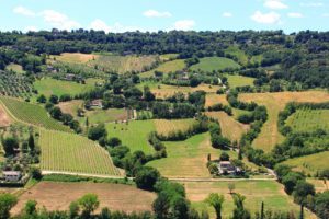
Visiting Orvieto and the uncontaminated countryside that surrounds it means being able to cover more than 140 km of roads and paths immersed in nature. The route starts from Orvieto and proceeds towards the Corbara lake, passing then for a stretch of the Tevere river park going up, the paths inside it towards the suggestive village of Osa and Colonnetta di Prodo.
 From here continue ascending the roads that lead towards Monte Peglia. After passing Montegiove, you reach the village of Montegabbione passing through the town of Castel de Fiori. It is from this point that the path, in a ring, reverses the direction and heads south through the village of Santa Maria and the village of Fabro. From this last Umbrian country you take a secondary direction towards Allerona. From here you enter then another large wooded area, that of Selva di Meana.
This stretch, beautiful from the naturalistic point of view is quite long and demanding, until the next destination: Castelviscardo. Here the path leaves the scenery of the forest to continue inside the streets of the village towards the plain of Alfina and the more modern village of Castelgiorgio. But before arriving at Castelgiorgio the “size” route to the small village of Benano. Once in Castelgiorgio the direction to take is the one towards Sugano. Before arriving at the village of Sugano you pass through an open country territory where the elegant profile of the castle of San Quirico stands out.
From here proceed uphill to get to the center of Sugano. You pass this village and the nearby village of Canonica then take and follow the signs that also mark the path known as the “ring of Monte Tigno” passing through hilly country areas and the path of the “Sasso Tagliato”. From here you can already see the cliff of Orvieto in the distance.